Where Dadaepo’s open beach gives way to a wooded headland
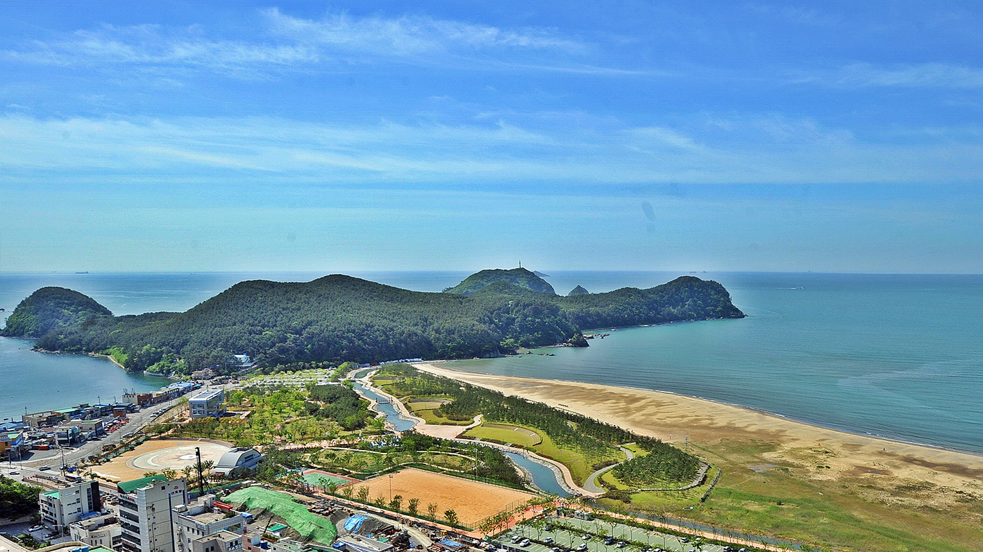
Dadaepo opens out into a broad expanse of sand and sky. Molundae, the wooded headland beside it, reveals the sea more gradually, through trees and gaps between rocks. Enter that dark green outline seen from the beach and the scale of the visit changes. Nearby bark attracts attention before the distant horizon does; the water appears and disappears as the path changes direction and height. This makes Molundae worth treating as a walk in its own right. Allow time for its woodland and historic buildings to form a connected experience, rather than arriving with only a few spare minutes for a photograph.
Three different timescales meet here. River-borne sediment gradually joined an island to the mainland; much older events remain recorded in the rocks; and monuments preserve memories of people who defended this coast. You need neither specialist geological knowledge nor a long hiking résumé to enjoy the place. A little context, along with regular checks on your energy and available time, is enough. This guide brings those stories together with practical directions for visitors unfamiliar with Busan, and suggests how to fit the headland into a day without rushing from one viewpoint to another.
An island that became part of the mainland
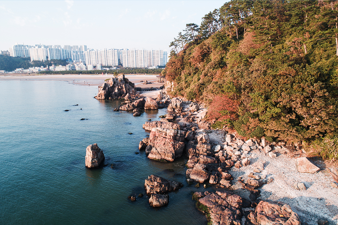
Molundae was once an island called Molundo. Sediment carried by the Nakdong River accumulated along the coast until it connected the island to the Dadaepo mainland. An island joined to land in this way is known as a tied island, with a connecting deposit often called a tombolo. Roads and the beach park now make arrival feel entirely ordinary, so its former isolation is not immediately obvious. Compare an elevated photograph with the landscape around you: the broad, low sandy ground and the rocky, wooded rise have distinctly different textures. Think of their connection as a long depositional process, rather than an event completed in a single identifiable year.
The name Molundae is traditionally explained as referring to an island disappearing into mist and cloud. It gives the landscape a poetic character, but it is not a promise of atmospheric fog or a spectacular sunset on every visit. Clear weather may reveal the bends in the coastline; overcast conditions can bring attention back to the woodland’s colours and the texture of nearby rock. Instead of spending the whole visit trying to recreate one famous photograph, look for what the conditions reveal that day. This approach gives the walk a purpose even when the sky does not match the forecast or your expectations.
Reaching the entrance by Metro Line 1
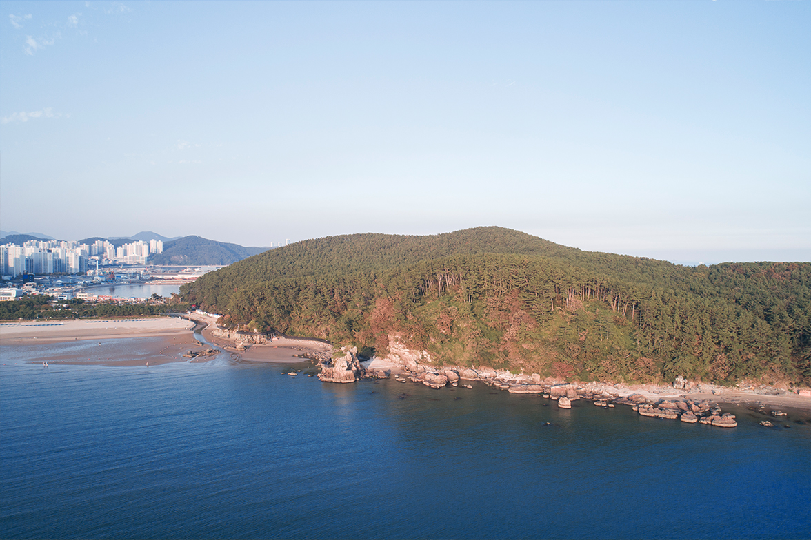
Use Dadaepo Beach Station on Busan Metro Line 1 as your transport reference. From Busan Station, Nampo or Jagalchi, take Line 1 towards Dadaepo Beach; at Seomyeon, check the direction of the same line before boarding. If you are staying near Haeundae, allow for the longer journey and the transfer from Line 2 to Line 1. Once outside the station, head into the beach park and towards the wooded eastern end, where Molundae stands. Arriving at the beach and arriving at the woodland entrance are different stages of the journey, so avoid setting only the general beach name as your walking destination.
Save 몰운대 or 몰운대 입구 in your map app, together with 다대포해수욕장역 for the return journey. English sources use both Molundae and Morundae, so checking the Korean name against the adjacent beach can prevent confusion. At the entrance, read the current map and opening notices before choosing a route. A low headland does not mean an entirely level walk: woodland slopes and coastal steps still require effort. Leave large luggage at your accommodation or a suitable storage facility. If using a wheelchair or stroller, ask which sections are currently accessible instead of assuming that the whole headland offers a step-free circuit.
Let the woodland set a slower pace
The woodland is part of the attraction, rather than an obstacle between you and the sea. One characteristic tree here is the Japanese black pine, known in Korean as gomsol or haesong, an evergreen conifer associated with coastal settings. You do not have to identify every plant to appreciate the walk. Notice the shape of trees exposed to the wind, the depth of the shade and the small openings through which the water becomes visible. Alternating between nearby foliage and the distant horizon makes the landscape feel layered even before you reach a viewpoint. There is no need to attach exaggerated health claims to the forest: a walk away from urban traffic has its own value.
Do not use up your energy on the initial climb. Changes in level and junctions may continue beyond it, and earth, stones and fallen leaves can be slippery after rain. Near the shore, the wind may feel stronger than it did beneath the trees. When stopping for photographs, leave room for others and avoid stepping backwards over roots or low edges while looking at a screen. With children, move together towards the next sign rather than letting the first glimpse of water turn into a race. A relaxed walk depends as much on keeping enough strength and daylight for the return as it does on walking slowly.
Dadaejin Dongheon: understanding the building in the forest
Dadaejin Dongheon is a surviving administrative building associated with Dadaejin, the coastal military post. A dongheon was a hall where a local official conducted public business; here it served the commanding official of Dadaejin. Its present wooded setting can make it look like a pavilion built to admire the view, but that was not its original purpose. After periods of other use, the building was moved and restored at this location in 1970. Knowing that it was removed from its original administrative setting helps distinguish the scenery around it today from the work once carried out inside.
Older maps and travel accounts may call it Dadaepo Gaeksa. That name arose from an incorrect identification during the relocation and was subsequently used for the protected building; in 2020 it was changed to Dadaejin Dongheon. Gaeksa and dongheon describe different institutional functions, so translating both simply as a historic guesthouse obscures the distinction. Look at the five bays across the front and two along the side, the spacing of the columns and the proportions of the roof. These exterior details convey the orderly character of the building. Follow local instructions about entering or using its raised floor, and do not cross barriers or lean against historic components for a photograph.
Jeong Un’s memorial: separating remembrance from the battlefield
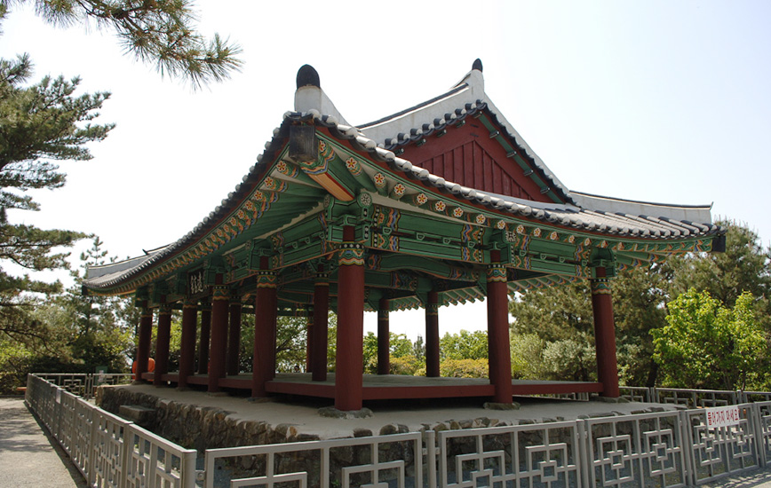
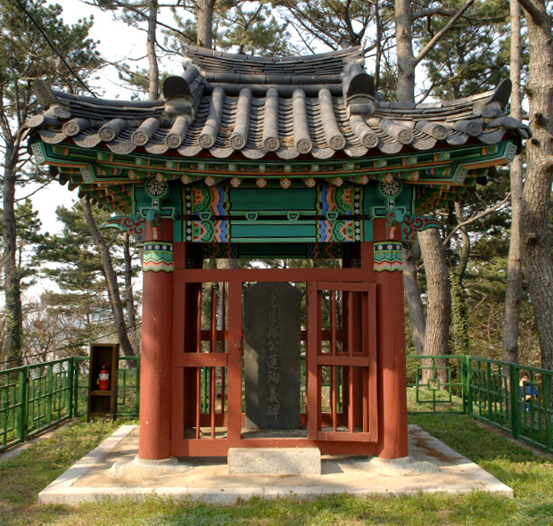
The Jeong Un memorial stele honours the commander of Nokdo, who fought under Yi Sun-sin during the Japanese invasions of Korea. Jeong Un died at the Battle of Busanpo in 1592. The monument came much later: his descendant Jeong Hyeok erected it in 1798 after taking up the post of commander at Dadaepo. Keeping these dates separate makes the site easier to understand. The stone is not a marker left on the day of the battle, but evidence of how later generations remembered a man’s service and death. The pavilion that shelters it was built in 1974.
A story links the sound un in Molundae with the same syllable in Jeong Un’s name, describing his resolve to die fighting here. The local heritage account distinguishes that inscription-based tradition from historical records of his death at the Battle of Busanpo. It would therefore be misleading to claim that he died on the exact spot where the monument now stands. Interesting travel stories deserve this separation between tradition and established events. Access also depends on the current situation: if the approach to the memorial is closed or restricted, do not enter. Use the open woodland paths and Dongheon visit to shape the rest of the walk instead.
Start reading the geology by looking for pebbles inside rock
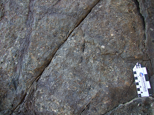
Molundae is a geosite of Busan National Geopark. It exposes the Lower Dadaepo Formation, deposited in the Late Cretaceous, along with evidence of later crustal deformation. Roughly 80 million years is a difficult timescale to imagine, but the smaller pieces within a rock offer an accessible starting point. Conglomerate consists of gravel-sized fragments cemented together with finer material. Unlike loose pebbles lying on the ground, these pieces are embedded in the rock itself and may differ in colour and size. Compare them with sandstone or finer-grained rock and it becomes clear that sedimentary rocks are not all made from the same-sized ingredients.
These materials preserve traces of environments in which sediment was transported and deposited. That does not mean a visitor can deduce an exact age or ancient river direction from a single pebble. It is enough to connect a feature you can see with the explanation on a nearby sign. If an outcrop is inaccessible, use photographs or interpretation material for its details rather than leaving the designated path. Striking the rock or removing a fragment takes away part of the record available to the next visitor. The most useful souvenirs are an ability to recognise different layers and grains, and photographs that show their wider setting.
Faults and mineral veins tell different stories
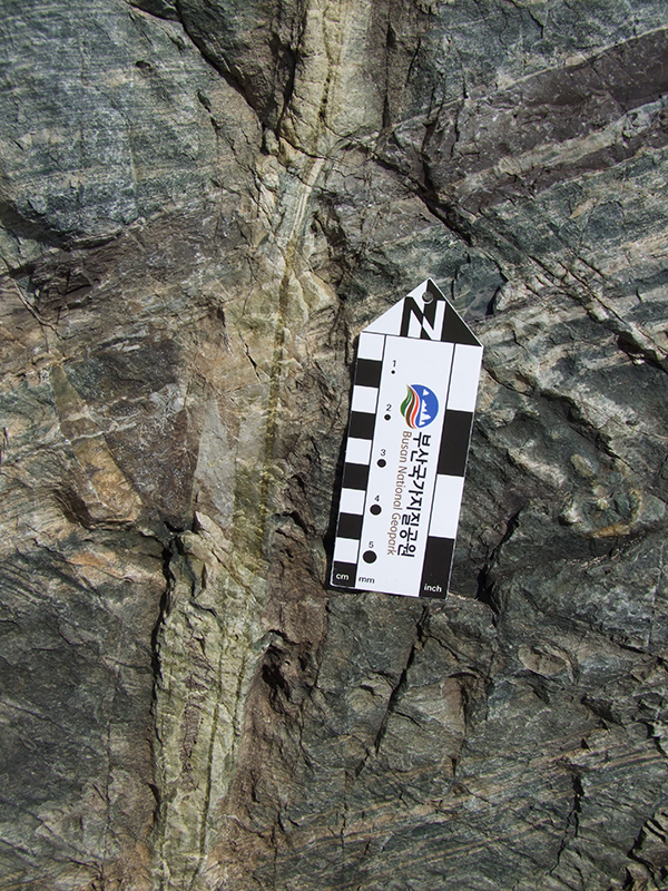
Along the geological trail, interpretation describes places where layers have broken or become displaced. A fault forms when rock fractures and the two sides move relative to one another. Molundae’s geological material includes a normal fault, in which the block above the inclined fault surface has moved down relative to the other side. A joint, by contrast, is a fracture without obvious relative displacement. For a beginner, the useful lesson is not to label every crack a fault. Follow the lines of a layer with your eyes and ask where the same layer continues on the other side: this turns an attractive pattern into a question about what happened to the rock.
A mineral vein records a different process. Hot fluids moving through cracks can leave dissolved substances behind as crystals, producing bands that contrast with the surrounding rock. Molundae has examples of pale quartz veins containing thin, dark green chlorite veins. Pebble-rich conglomerate, offset layers and mineral-filled cracks therefore represent different parts of the geological story. Learning to distinguish these three features already makes a rocky shore much more interesting. Close-up photographs containing geological scales help explain details; they are not directions for visitors to climb down to the same research or photography position.
Seeing the coast from inside and outside the trees
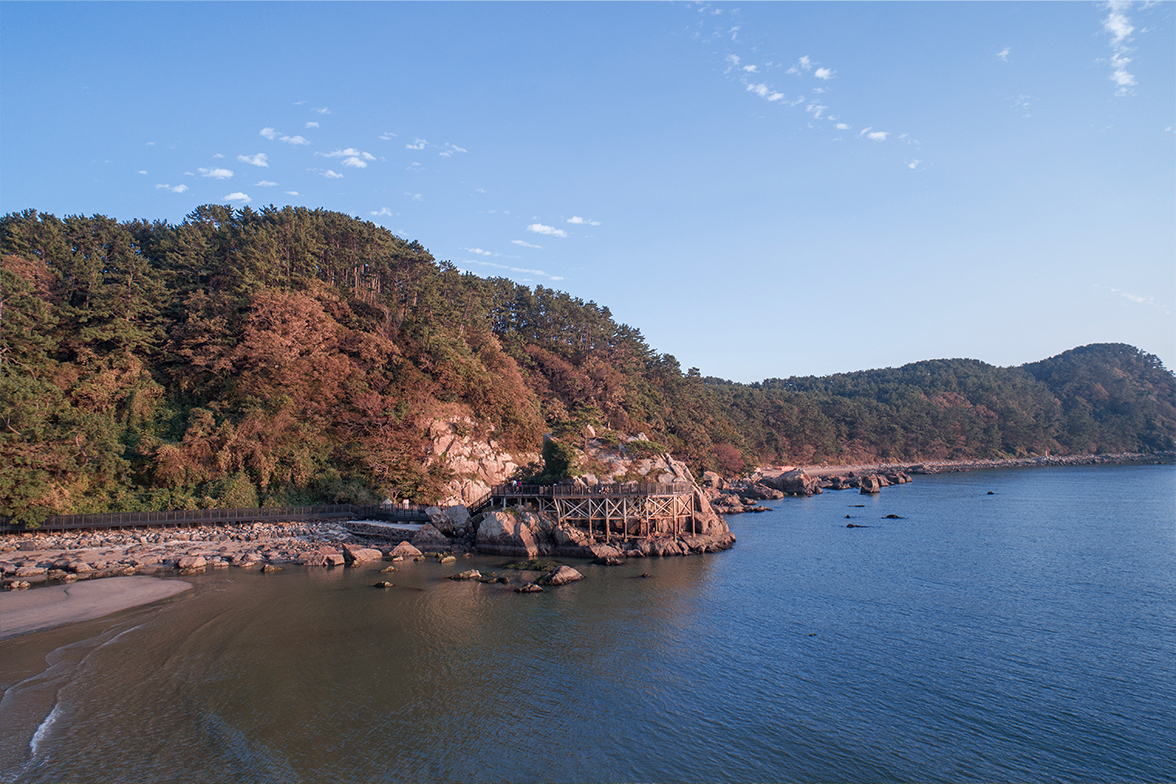
Wave-cut rock and an irregular shoreline characterise the southern and surrounding coast of Molundae. In the woodland, the water may appear as a narrow framed view; from an open public viewpoint, rocks, sea and distant island silhouettes spread across a wider scene. You may also encounter the name Hwason-dae, referring to a sea-facing platform at the eastern end of the Molundae area. Rather than treating every outlook as the same viewpoint, compare the direction you face with the map. This helps distinguish views back towards the beach from those towards open water. If an island’s name is uncertain, understand its position before trying to identify it.
The western sunset viewpoint and wooden deck are useful places to connect Molundae visually with Dadaepo Beach. Local information describes a deck approximately 346 metres long, but that figure is not the distance of a complete woodland circuit and does not guarantee that every section is open. Check the route available that day. The rocks below a deck may seem to offer a better camera angle, yet wet stone and waves create conditions very different from a maintained walkway. Choose a view available from within the barriers. Seeing every metre of shoreline is neither necessary for understanding the place nor a sensible measure of a successful visit.
A first visit: woodland, Dongheon and one viewpoint
For a first visit, start with the entrance map, follow the woodland route to Dadaejin Dongheon, add one viewpoint that is open that day, and return to the entrance. Allow roughly ninety minutes to two hours if you want time for reading, photography and pauses. This is a suggested planning allowance, not an official walking time or a guarantee of completing every branch. Set a return time at the start and check it again before heading to the farthest point. Add the Jeong Un memorial only when access permits; if its approach is closed, keep the route simple.
Even a shorter walk becomes substantial when you give it a sequence of questions. In the forest, look at how the trees meet the wind. At Dongheon, think about the building’s original use. At the viewpoint, compare the rocky rise with the sandy shoreline. Three observations made carefully can stay with you longer than many places passed in a hurry. Solo visitors should leave time to check their position at junctions; friends travelling together should allow for different photography and walking speeds. If heat or limited mobility makes the coastal extension difficult, a shorter woodland and heritage visit can still fulfil the purpose of coming.
A half-day ending with Dadaepo’s sunset
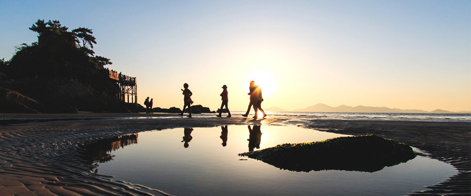
With half a day available, walk Molundae while there is plenty of light, then move out to the beach park and Dadaepo’s open sand. One workable sequence is an early-afternoon arrival, woodland and Dongheon, a meal or snack outside the entrance, and the beach as sunset approaches. Allow around four hours with breathing room for transfers between these stages and for breaks, adjusting the actual schedule to that day’s sunset. In winter, start the afternoon programme earlier. This makes it easier to enjoy both the woodland and the evening sky without turning the return from the headland into a rush.
Adding Gouni Ecological Trail or Amisan Observatory increases the distance and the number of transitions. Molundae’s rocky coast, Dadaepo’s sand and wetland, and Amisan’s overview of the Nakdong estuary belong to a connected landscape, but they are separate places. Choose a main interest before adding them all. Give Molundae more time if woodland and history are your focus, or reserve a separate viewing period for the wider estuary. Staying into the evening does not automatically mean there will be a fountain show. Dadaepo Sunset Fountain operates seasonally, so check the programme for the relevant year before building the evening around it.
Let the season and opening hours shape the walk
Published opening hours for Molundae are 05:00–20:00 from April through September and 06:00–18:00 from October through March. Outside those hours, the area is controlled by the military at night. A busy, illuminated beach outside the woodland does not imply permission to remain inside. Treat closing time as the point by which you should be out, rather than the moment to reach your final viewpoint. In the shorter days of winter, the trees can make a path feel dark before the open shore does, so plan an earlier return. Temporary restrictions and instructions on site take priority over the general timetable.
Summer shade does not remove the effects of humidity and climbing, so carry enough water. In winter, an outer layer that blocks the wind is useful at exposed viewpoints. Rain or strong-wind forecasts are reasons to reduce the coastal part of the route, and poor ground conditions may justify shortening the whole walk. Choose footwear that grips wet earth and steps. It is more practical to check weather and access together before setting off than to rely on a small umbrella while committing to a long coastal route. The conditions for returning comfortably matter more than achieving a distance chosen in advance.
Making photographs, breaks and meals fit naturally
Pair a wide view with a close detail to convey Molundae’s character. A photograph of the wooded headland followed by pebbles embedded in rock or the eaves of Dongheon connects scenery with its story. When shooting towards bright water, check the sky’s exposure on your phone; decide whether people should be recognisable or appear as silhouettes. Respect other visitors’ wishes when their faces are prominent in a photograph you intend to publish. Avoid photographing military facilities or anywhere marked with a restriction, and do not assume that a scenic coastal location permits unrestricted drone flights.
Prepare water and a light snack before entering the woodland, then place a fuller meal back around the station or beach to keep the route straightforward. When choosing a restaurant, check whether a single-person order is possible, how spicy the seasoning is and whether seafood or meat stock is used. If you have dietary restrictions or allergies, prepare a translated ingredient question rather than relying only on menu photographs. Leave passageways clear when resting and carry food scraps and packaging away with you. After a break, recalculate the time needed to leave the woodland so that a leisurely snack does not lead to a late return.
Names and practical details to save before arrival
Molundae occupies the area around san 144, Dadae-dong, Saha-gu, Busan. General tourism enquiries are listed at 051-220-4524. For heritage matters concerning Dadaejin Dongheon or the Jeong Un memorial, Saha-gu’s culture and arts department lists 051-220-4085. When calling from abroad, use South Korea’s +82 country code and omit the first zero of the area code. Saving 몰운대, 다대진 동헌 and 다대포해수욕장역 in your map app helps separate the entrance area, a key visit and the station for your return. If you want a guided interpretation, check operating days, reservations and available languages beforehand; do not assume a foreign-language guide will be immediately available on arrival.
A rewarding Molundae visit is less about counting viewpoints than connecting what you see. The sand that joined a former island to the mainland, the older record inside the rocks, a relocated administrative hall and a monument erected generations after a battle all add substance to a short walk. With those connections in mind, even Dadaepo looks different on the way back. Choose open paths that suit the weather and your energy, return from the woodland in good light, and leave the final unhurried stretch for the beach. That simple sequence is enough to make Molundae a centrepiece of a day in western Busan.
Reviews 1
Rain gear
Public visitor review summary
Fog obscured the sea; sudden rain meant using the raincoat and umbrella I had packed.
A little closer to Korea.
Thank you for reading.