Following a small stream towards the beginning of a great river
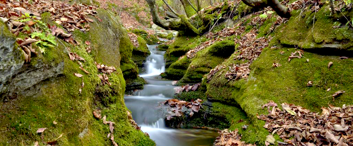
Geomnyongso in Taebaek begins with nearby water and stone rather than a monumental waterfall seen from a distance. A low stream accompanies the forest path; closer to the spring, white water bends repeatedly between moss-covered rocks. If you know the broad Hangang in Seoul, the modest scale here becomes part of the interest. Finding the beginning of a river means looking closely at a small place where underground water emerges. The changing sound of the stream and the depth of the forest can be as memorable as a photograph beside the destination marker.
Reaching the spring does not require a summit climb. The route follows the valley from the car park and returns along the same path, with steps and viewing decks near the end. For a first visit, allow roughly 90–120 minutes for the approximately 3 km return walk, spring observation and pauses. This is a suggested sightseeing duration, distinct from the official one-way walking estimate. The outing can fit into a trip from central Taebaek, but treating the forest approach and the emergence of the water as one experience explains the place better than checking the spring quickly and leaving.
Understanding the scale of a river source
Geomnyongso is one of Taebaek’s defining natural attractions, known as the source of the Hangang. Descriptions of the river’s approximately 514 km length connect its distant upper reaches with this woodland spring. Taebaek’s visitor information records its official recognition as a source in 1987. That date does not mean the water first appeared in that year. Surveys followed the river upstream and established connections between waterways, giving the site its geographical significance. Between the little mountain spring and the broad urban river lie many tributaries and confluences.
Water from here continues through Goljicheon and the Joyanggang in Jeongseon, then the Donggang in Yeongwol and the Namhangang system. At Dumulmeori in Yangsu-ri, Gyeonggi-do, the Namhangang meets the Bukhangang to form a wider Hangang flowing towards the West Sea. The whole journey does not use one name, nor does the volume visible here alone fill the river in Seoul. Before walking, locate Taebaek, Jeongseon, Yeongwol and Yangsu-ri on a map. Simply noticing the direction in which water leaves this valley can extend the visit beyond the forest immediately around you.
Where underground water returns to the surface
Geomnyongso is a spring where water that has infiltrated underground around Geumdaebong emerges again through limestone. Part of its journey therefore happens out of sight before it reaches the visible stream. Think of water entering the ground on the mountain, gathering below and reappearing before running down the valley. This sequence clarifies the relationship between spring and stream. The surrounding rock is more than a background: it belongs to the environment through which the water has travelled. Alternating between the spring’s movement and the faster flow below reveals different appearances within the same waterway.
The described discharge is approximately 2,000–3,000 tonnes per day, with water around 9°C throughout the year. The spring is described as having a circumference of about 20 metres; this is not a width or diameter of 20 metres. These approximate figures help explain its character. They offer a way to understand flowing water in cold weather, but do not mean that the surrounding air or decks remain at the same temperature. In winter photographs, the contrast between open water and snowy edges becomes especially clear. Follow the small movements on the surface through to the foam travelling below the rocks.
The forest path from the car park to Sesim
The walk starts at Geomnyongso car park. About 100 metres along the paved approach is the area with toilets and the Geomnyongso branch office, a useful place to complete preparations before heading towards the spring. Beyond the entrance marker identifying the source of the Hangang, the route continues over earth and stones. National park guidance gives 0.9 km and about 20 minutes from the car park to Sesim Visitor Support Centre. Treat that as a walking estimate rather than assuming it includes every pause for trees or photographs.
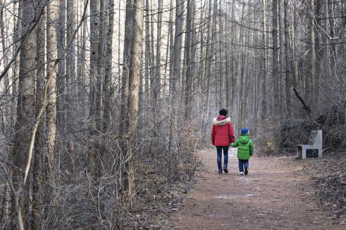
Going uphill, the stream lies mainly to your left and woodland shades much of the path. When the trees carry leaves, nearby trunks and water draw attention; after leaf fall, the opposite slope and overlapping branches become more visible. The route’s interest does not begin only at the spring. Listen to the changes where water spreads or narrows, and notice rock colours and places where leaves collect. Exposed stones alternate with smoother earth, so stopping briefly to look is more comfortable than constantly turning your head while continuing to walk.
Across Sesimgyo and towards the final junction
Near Sesim Visitor Support Centre, the route to Geomnyongso turns left. The remaining distance is listed as 0.6 km, taking about 15 minutes. After the wooden Sesimgyo bridge, benches and resting places punctuate a section that gradually gains some slope. It is useful to remember the centre as a route landmark rather than plan around an assumption of indoor rest services always being available. On the return, this point also helps judge the remaining distance to the car park and coordinate the pace of your companions.
Another junction appears about 200 metres before the spring. The left-hand direction leads to Geomnyongso, while the right is marked towards an ecological forest restoration area. Follow the spring signs instead of choosing a path merely because it looks wider or quieter. Some surrounding mountain routes are separately managed, so a brief detour should not be assumed to reconnect automatically. The short walk’s aim is to follow the valley to the spring and back. Remembering the two junctions and the wooden bridge makes that structure clearer and reduces unnecessary wandering on the return.
Viewing the spring from wooden steps and a circular deck
Near the destination, the path becomes wooden steps and decks. These facilities provide viewpoints while protecting rock and moss around the water. Midway up the steps is a place to photograph the valley, and the upper circular deck offers different angles over the emerging spring and its outflow. Attend to the changes in step height while climbing, then study the water when you reach a place to stand. People use the route in both directions, so leave room to pass if you spend time composing photographs.
From above, look first at the spring’s surface, then follow the direction in which water exits and drops between rocks. The same water can appear as gentle movement at its emergence and a fast stream within a narrow groove. Connecting the white cascades seen lower down with the spring above is central to this walk. Rather than expecting one enormous waterfall, observe the source together with the slope that carries the water away. Not every position on the circular deck offers the same view; a few permitted steps can change how rock and water overlap.
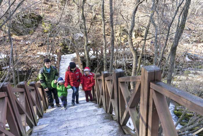
Moss, wet rock and the colours of the valley
Green moss often dominates photographs of Geomnyongso, but the scene contains more than one colour. Channels directly carrying water can be dark or reflective, while nearby rocks hold layers of moss and fallen leaves. White water, the deep tones of wet stone and light between branches work together. You do not need to identify each moss species to find something interesting. Comparing surfaces close to water, slightly higher up and in shade already reveals differences within a small area.
Thick-looking moss does not need to be pressed by hand or inspected by stepping down onto rocks. What is visible from the deck provides clues to the waterside conditions. Leafy woodland and fallen autumn leaves change how the same stone appears through surrounding colour. In photographs, keeping the relationship between water and rock clear often captures the place better than simply exaggerating the green. After a closer image, include the surrounding trees as well. This shows that the spring belongs to a continuous forest environment, rather than an isolated pile of attractive stones.
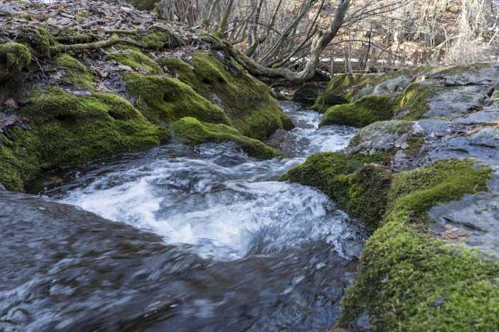
Water descending through grooves in the rock
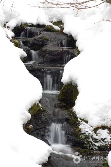
Below the spring, the water does not fall in one straight line. It changes direction along curved channels and drops wherever the rock changes height. The shapes are explained as the result of long periods of flowing water wearing the bedrock, with grooves described as about 1–1.5 metres deep and 1–2 metres wide. These measurements refer neither to the spring’s size nor to the footpath. From below, successive drops enter the view together; from the side, the bends become easier to follow. Observing how rock gathers and releases the flow is a useful starting point.
A single photograph does not convey all of that movement. A brief exposure can show foam and splashes clearly, while a longer exposure turns the same stream into soft white lines. Different photographic appearances do not necessarily indicate different amounts of water. On site, combine sight with sound and take photographs from the deck where standing is permitted. A vertical frame suits successive drops, while a horizontal frame includes the rocks and forest around them. Changing the framing provides variety without crossing a railing to make the water look larger.
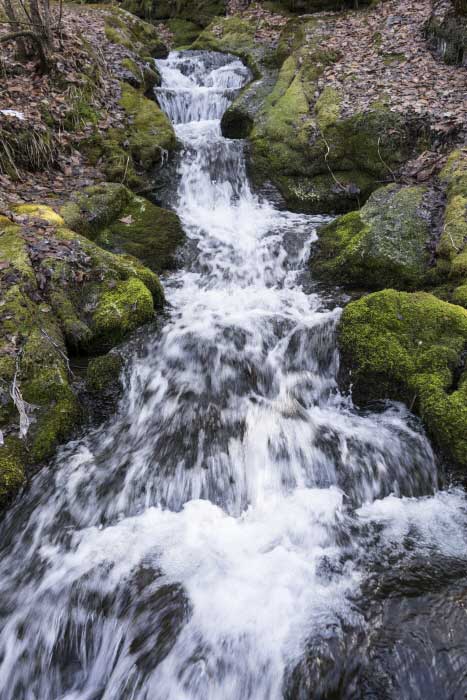
The serpent that wanted to become a dragon
A legend accompanies Geomnyongso’s name. Geomnyong is explained as an imugi, a serpent that has not yet become a dragon, while so means a deep pool holding water. In the story, an imugi living in the West Sea travelled upstream in its quest to become a dragon, reaching the farthest spring. Its writhing as it tried to enter the pool supposedly created the grooves and falls. Looking at the twisting watercourse makes it easier to understand why people imagined a giant body moving through the rock. Erosion explains the physical process; the serpent story remembers the landscape through imagination.
The tale continues with the creature eating cattle that came to drink, leading villagers to fill the spring with earth. Fear of deep water and its force becomes connected with everyday life. Modern source surveys and restoration should be understood separately from that legend. Investigations and restoration work in the 1980s helped establish Geomnyongso as the visitor destination known today. Rather than memorising one restoration date, it is more useful on site to recognise the different layers of oral tradition, modern geographical research and facilities added for visitors.
Watching closely while keeping out of the water
Geomnyongso was designated a Scenic Site on 18 August 2010. Its protected landscape includes the watercourse, rocks and forest, not only a single point where water appears. A deck beside or above the stream does not authorise stepping down into it: entry into all flowing water within the Geomnyongso section is prohibited. Even in summer, plan this as a place to observe rather than paddle, drink from the spring or fill a bottle. Establish before setting out that the visitor route and the water itself are separate spaces.
Following the bridges and decks lets you see the same watercourse from several heights, keeping the visit varied without entering it. Leaving moss and small stones where they are also helps retain the scene. With children, you can focus attention on finding where water emerges and which channel it follows rather than only repeating prohibitions. Direction of flow, places where foam forms and leaf-filled edges can all be studied with the eyes. Leaving the spring room to keep flowing is part of how this river source is visited.
The forest through the seasons and the winter stream
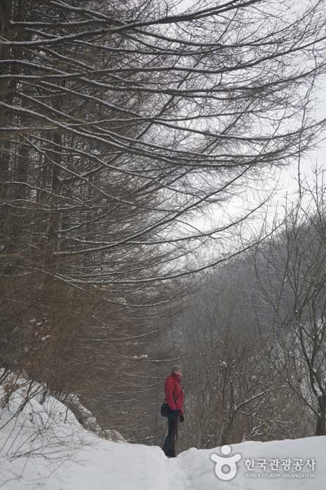
Spring brings unfolding leaves, summer deeper shade, and autumn contrasts between leaf litter and moss. In the bare-season forest, as in the path photograph, the spacing of trunks and direction of the trail become more evident. One year’s image is not a promise of identical colour on the same date. Taebaek’s changing temperatures and recent rainfall affect both foliage and the path. Rain may deepen rock colours while changing walking conditions, so a day with stronger-looking flow is not automatically the best day to visit.
Winter offers a distinctive contrast between snow-covered woodland and exposed water. The spring emerging at around 9°C describes the water, not a guarantee that the path remains unfrozen. Snow or ice can linger on shaded slopes and wooden steps. Check opening and surface conditions, and prepare traction appropriate to the day; winter trail guidance specifically mentions crampons or ice grips on the sloping section. Allow generous time for both directions instead of hurrying for a snow photograph. If the steps prove difficult, limit the visit to what is manageable that day. Observing winter water and preparing for a winter path belong together.
Entry-control times are not a sightseeing timetable
The national park’s entry-control table lists the Geomnyongso branch office to spring section as 04:00–17:00 from November to March and 03:00–18:00 from April to October. These are trail entry and restriction limits, not the business hours of every office, toilet or other facility. Nor do they recommend arriving late and expecting ample time to explore and return. For a first visit, a round trip in daylight is easiest to plan. Calculate the return to the car park as well as the initial departure.
Weather or local restrictions can close a route even within its listed times. When heavy rain or snow is expected, or surfaces are uncertain, check national park trail-control information before travelling. Taebaeksan National Park can be contacted on 033-550-0000. This is a natural trail, so distance and remaining daylight are more useful planning tools than treating the cutoff like last admission to an indoor attraction. Pauses at Sesim and photographs around the spring add time. Avoiding a late arrival keeps the overall arrangement much simpler.
Separate the spring walk from reserved mountain hikes
Not every search result containing Geomnyongso refers to the same walk. The reserved route from Dumundongjae through Bunjuryeong and Daedeoksan towards Geomnyongso is a separate mountain itinerary. Listed at 8.7 km and about four hours, it starts elsewhere and is different from the 1.5 km one-way walk from the car park to the spring. Broad meadows or wildflowers in mountain-hiking accounts should not be expected as compulsory sights on this short forest route. Decide first whether the purpose is the spring or a hike involving ridges and peaks.
The reserved mountain route has a managed season and visitor limits. Its current information lists 27 April to 30 September, so do not simply attach that hike to a late-autumn spring visit; consult the appropriate season’s notice in a different year. A one-way traverse also ends at Geomnyongso rather than its Dumundongjae starting point, requiring a vehicle-retrieval or onward-transfer plan. The official guidance notes the absence of public transport connecting the two. Visitors making only the spring return walk need to check their own trail’s current conditions, without combining it with the distance and transport of a separate traverse.
The final journey from central Taebaek
Geomnyongso is a mountain source near Changjuk-dong, not a pond in the middle of Taebaek’s urban centre. For navigation, check Geomnyongso car park together with 475-2 Geomnyongso-gil, Taebaek-si, Gangwon State. Some information uses the older land address San 1-1, Changjuk-dong. Set the vehicle destination by the car park and approach, rather than assuming you can drive to the spring symbol on a map. After arriving at Taebaek Station or the intercity bus terminal, another journey and the return walk from the car park still remain.
With public transport, check current services from your starting point, the alighting location and any final walking segment together. An old tourist-map timetable should not be treated as current; establish the return service for your date too. If arriving by taxi, arrange a recognisable meeting place such as the car park, and confirm the return time and pickup possibilities. Drivers also need to separate parking time from time spent inside the valley. If a meal in town or a train follows immediately afterwards, avoid postponing departure from the spring until the last possible moment.
How to use 90–120 minutes at your own pace
You do not need to take every photograph on the outward walk. One approach is to enjoy the forest towards Sesimgyo, spend time understanding the spring and the cascading channel, then revisit favourite scenes on the way back. The path is the same, but the direction changes your relation to sound and incoming light. Doubling the roughly 35-minute one-way walking estimate gives 70 minutes; observation above the steps and rests naturally bring the stay towards 90–120 minutes. Companions walking at a different pace may need longer.
Although described as a relatively gentle walk, the whole route is not a smooth, step-free path. Earth, stones, exposed bedrock and the final wooden steps make stroller and wheelchair use difficult. With young children, consider the actual distance and stairs; if someone has limited mobility, ask about a feasible extent before visiting. Walking only partway from the car park to enjoy the forest is an option, but that does not mean the spring will be visible from the turnaround point. Match the desired sight with the reachable location when shortening the route.
Connecting Taebaek’s water stories at Hwangji and Samsuryeong
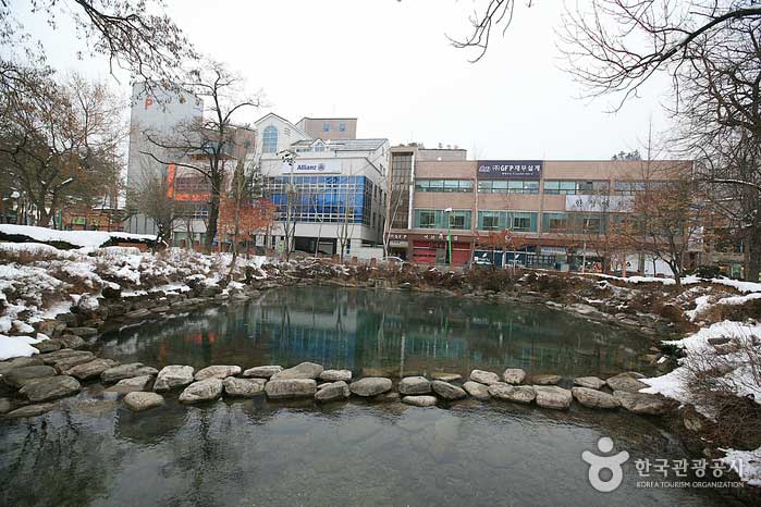
If adding one more stop, Hwangji Pond in central Taebaek provides a useful comparison. Known as the source of the Nakdonggang, it brings emerging water close to buildings and daily urban life, rather than between rocks at the end of a forest path. Seeing both shows that river sources need not look alike. At Geomnyongso, grooves and moss guide the eye; at Hwangji, the relationship between the water surface and the surrounding town becomes prominent. The beginnings of different rivers shaping one city’s travel themes are part of Taebaek’s character. The sites are separate, so allocate travel and meal time accordingly.
Samsuryeong offers another perspective. It is described as a watershed where rain drains towards the Hangang, Nakdonggang and Osipcheon systems, continuing respectively towards the West, South and East seas. Samsuryeong is not the Geomnyongso spring itself, and Hwangji is not another name for it. Distinguishing groundwater emergence, a river’s source and terrain directing drainage makes the day clearer. If time is short, Geomnyongso alone is enough. You may enter the forest thinking of the great name Hangang, but leave with a concrete image of small amounts of water joining and travelling far.
A little closer to Korea.
Thank you for reading.